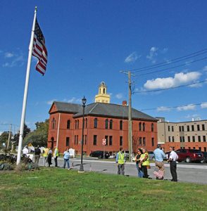
Fairhaven town officials and state officials visit Benoit Square in Fairhaven trying to find solutions to current and increasing traffic congestion at the poorly designed merger of Main and Adams Streets, on 9/27/22. Photo by Beth David.
By Beth David, Editor
Officials from MassDOT (Mass. Department of Transportation) and SRPEDD (Southeast Regional Planning and Economic Development District) met with Fairhaven town officials and members of the North Fairhaven Improvement Association on Tuesday, 9/27/22, to talk about problems and solutions to the traffic woes at Benoit Square. Rep. William Straus, Fairhaven’s state representative and a member of the House’s Joint Committee on Transportation, also attended.
The meeting started in the NFIA building which is right at the square, and officials then crossed the street to see traffic for themselves.
Benoit Square is actually a triangle where Main Street and Adams Street merge. The green has a gazebo and memorial to Ernest J. Benoit who was killed in action in World War I; a memorial to all Veterans of Foreign Wars; and a memorial to Patrick J. Gallagher, who was killed in Iraq in 2006.
Howland Road is on the south side of the triangle and leads to New Bedford to the West and Alden Road in Fairhaven to the East. Main Street is on the western side, and Adams Street is on the eastern side.
On Adams Street, the new Oxford School Residences have just started accepting tenants into 52 apartments. Across the street, the old Bijou Building is also getting ready to rent out a number of apartments. NFIA members and town officials are concerned that the increased traffic from those changes will significantly affect the area.
Adams Street is a state road/ highway along the square, and Main Street is a state road from the end of the square on the northern side all the way to Acushnet.

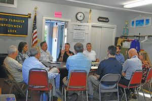
Fairhaven Police Chief Michael Myers (RIGHT) points out something on the map at a meeting to discuss traffic woes at Benoit Square on 9/27/22 at the North Fairhaven Improvement Association building, L-R: NFIA member John Medeiros, Fairhaven Town Administrator Angie Lopes Ellison, Fairhaven Fire Chief Todd Correia, Chief Myers. Photo by Beth David.
Fairhaven Town Administrator Angie Lopes Ellison said the situation suddenly seemed critical when she realized that significant amounts of traffic will be rerouted to the corner of Howland Road during work on the Fairhaven-New Bedford Bridge, which is now in the planning stages.
Currently, the intersection is quite the headache when the bridge closes, which is, generally, every hour, on the hour. The bridge closes to vehicle traffic to allow boats to pass through.
All officials agreed that the increased traffic during shutdowns required for the replacement of the bridge, is bound to cause even more headaches.
On the other side of the triangle, where the merger point is, the problem is a poor design that leaves drivers with no idea where to go, or who has the right of way. Those taking a left from the Oxford Residences, or from the side streets on the western side, cross four lanes of traffic to make the turn.
“You can’t figure out which way to go,” said Ms. Ellison.
“We’re really here to hear from you,” said Pam Haznar, from Mass DOT/Project Development,
Louis deOliveira, from SRPEDD said a crash analysis showed that there were not really a lot of crashes, but a there were a lot of rear ends, with 62% on Howland and Main.
It was a bit of a surprise to most locals there, because the bigger issue seemed to be the other end of the square.
“It creates an unknown area for vehicles heading north,” said Rep. Straus. “You don’t know whether to go left or right. There is no clear lane of travel.”
“It’s a confusion,” said Fairhaven Police Chief Michael Myers, and police officers need to made a determination if there is an accident.
There is a “huge open area,” said Chief Myers, which causes the confusion to drivers.

Although the project is welcome by the town to repurpose the old Oxford School building, the new Oxford School Residences, with its 52 apartments, is bringing more traffic to Benoit Square. Photo by Beth David.
Fairhaven Planning Director Paul Foley said it was a “miracle” that there were not a lot of crashes there. He said one just had to sit for a half hour to see that half the people on Main Street do not even look for the traffic merging from Adams Street.
“It’s a miracle,” he said. “I bet there’s been a thousand close calls.”
The group also discussed parking along the roads and off street.
Part of the Oxford project included adding 30 public parking spaces on the Livesey Park side of the building. But most people do not know about them, said NFIA member John Medeiros.
His focus, he said, was to fix things between Morton Street, which borders the Oxford building on the north, to Howland, which is the end of the square.
“Nobody knows that lot’s available,” said Mr. Medeiros, adding it would help if people used that lot instead of the street.
Mr. Medeiros also pointed out that there are conflicting speed limit signs and not enough of them.
He asked if they could get merge signs and other signs to make clear who has the right of way.
“Because the one who has the right of way is the biggest truck, all the time,” said Mr. Medeiros.
State officials explained that certain rules apply to signage depending on if it is to slow down traffic, control traffic, or just warn drivers of what is ahead. Some signs the town can do on its own, others require state approval. Then add the complication of part of the roads being state, and not local.
Town officials asked if the state could do something similar to what was used on Sconticut Neck Road at David Drown Boulevard, using stanchions as a temporary block to narrow the road.
State officials named a number of things they could do right away, while working on more permanent solutions, such as tinkering with the timing of the light signals, using stanchions, and adding signage.
David Soares, Mass DOT Traffic Operations, said the technology on the existing lights does not allow for adjustments to current conditions. ‘
“They’re pretty simple,” said Mr. Soares, but also said there were some things they could try.
The group also discussed the possibility of placing bridge closed/open signs near the Route 240 exist to get people to use Rte. 195 to Rte. 18, instead of heading for the bridge, finding it closed, and taking the right onto Main Street, which clogs up Benoit Square.
The state is also performing a truck study, and local officials asked about rerouting larger trucks away from square. Mr. Soares said the state is not allowed to ban trucks, but the town can limit the trucks from using the side streets, which is another headache for residents.
Mr. Soares said there are a number of tools the town can use to minimize truck headaches for residents, including limiting the time when trucks can use certain roads. The limits would only apply to large trucks, he said, determined by weight, so regular delivery trucks would not be affected.
The trucks from PJ Keating in Acushnet would be subject to the restrictions, but not on the state roads.

Fairhaven officials, state officials and local residents meet to talk about traffic woes around Benoit Square, on 9/27/22 at the North Fairhaven Improvement Association building. Clockwise: North Fairhaven Improvement Association member John Medeiros head of table); Fairhaven town Administrator Angie Lopes Ellison; Fire Chief Todd Correia; Police Chief Michael Myers; Police Lt. David Sobral; Louis deOliveira, Southeast Regional Planning and Economic Development District; Lisa Estrela-Pedro, SRPEDD; Pam Haznar, Project Development, MassDOT; Bob Wheeler, Project Development, MassDOT; David Soares, Traffic Operations, MassDOT; Paul Foley, Fairhaven Planning Director; Rep. William Straus. Photo by Beth David.
In the end, state officials said they would come up with some short term, temporary suggestions for the town to implement right away, and then would continue to work on long term solutions.
Short term solutions including signal timing for the two sets of lights on Howland Road.
Chief Myers made his plea for some way to establish more clearly who has the right of way, with use of stanchions or other solutions the state officials may come up with.
The deadline is for solutions to be in place before the bridge project starts.
There are two meetings to discuss the bridge replacement project. The first meeting will be held this Monday, 10/3 at the Fairhaven High School Auditorium from 6:30 p.m. until 8:00 p.m. The second will be held on Thursday, 10/6, at the New Bedford Vocational Technical High School Auditorium from 6:30 p.m. until 8:00 p.m. Public participation is encouraged. A virtual option will also be offered for those who cannot attend in person.
Of course, no meeting with state officials would be complete without bringing up unrelated issues.
Chief Myers asked officials if there was some way to create more awareness of the high school on Route 6, especially the crosswalk that is between two sets of lights, and difficult for drivers to see.
He also asked about more signage on Adams Street, a state road, near the middle school.
Mr. Soares said there is some federal guidance on how to handle school crossings, and high schools will soon be able to be included, as before, only lower grades could be considered school zones.
•••
Click here to download the entire 9/29/22 issue: 09-29-22 BenoitSq
Support local journalism, donate to the Neighb News with PayPal


