
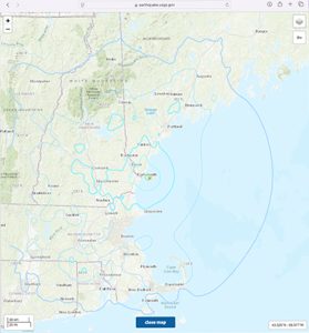
This map from the US Geological Survey website shows the impact area of the 3.8 magnitude earthquake felt from Maine to Connecticut on 1/27/25 at 10:22 a.m. Screenshot from USGS website.
By Beth David, Editor
An earthquake that started off the coast of Maine, shook homes all the way to Rhode Island on Monday, 1/27/25 at about 10:22 a.m. The 3.8 magnitude earthquake’s epicenter was about 10 km/7 miles southeast of York, ME.
The US Geological Survey online showed the effect of the earthquake reaching as far south as Cape Cod in Mass. and Hartford, CT, and as far north as Augusta, ME. The Tsunami Warning Center in Palmer, AK, said there was no tsunami danger from the earthquake. There were no injuries or damages reported.
According to the USGS, New England has had earthquakes since colonial times. Moderately damaging earthquakes strike somewhere in the region every few decades, and smaller earthquakes are felt roughly twice a year.
According to USGS: “The Boston area was damaged three times within 28 years in the middle 1700’s, and New York City was damaged in 1737 and 1884. The largest known New England earthquakes occurred in 1638 (magnitude 6.5) in Vermont or New Hampshire, and in 1755 (magnitude 5.8) offshore from Cape Ann northeast of Boston. The Cape Ann earthquake caused severe damage to the Boston waterfront. The most recent New England earthquake to cause moderate damage occurred in 1940 (magnitude 5.6) in central New Hampshire.
Massachusetts experienced three earthquakes in 2024 and all were below 2 magnitude.
Details of the earthquake can be found at https://earthquake.usgs.gov/earthquakes/eventpage/at00sqr6q8/shakemap/intensity

This “shake map” from the US Geological Survey website shows the specific areas where houses shook from the 3.8 magnitude earthquake felt from Maine to Connecticut on 1/27/25 at 10:22 a.m. The interactive map allows users to click on a circle to get specific information, such as intensity. Screenshot from USGS website.
•••
Click here to download the 1/30/25 issue: 01-30-25 NewOfficers
Support local journalism, donate to the Neighb News with PayPal