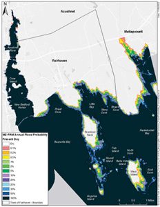
This present day map shows the probability of flooding in Fairhaven now during storms, with much of the coastline in all parts of town in the 10 to 20% chance range. Graphic courtesy of Woods Hole Group.
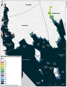
This map shows the probability of flooding in Fairhaven in the year 2070 based on a 4.5 foot sea level rise scenario, which is a worst case scenario, and dramatically pushes back the land compared to the present day map. Graphic courtesy of Woods Hole Group.
By Beth David, Editor
Fairhaven officials, consultants, and state officials held a public meeting on Wednesday, 2/8/22, to discuss the growing threat of flooding along the coast during storms. The Municipal Vulnerability Preparedness (MVP) meeting allowed residents to voice their concerns and tell officials where the flooding is getting worse in their neighborhoods. The project is in the information gathering stage to identify critical infrastructure that may need to be raised or moved to prepare for climate change.
Fairhaven Town Planner Paul Foley told the group of about 40 that the maps will “shock” them, showing how land along the coast will be swallowed up by rising seas.
Conor Ofsthun, Coastal Scientist a the Woods Hole Group, the town’s consultant, told residents that the primary goal for the evening was to get more feedback from them.
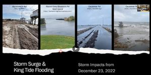
In this screen shot from the Municipal Vulnerability Preparedness meeting in Fairhaven on 2/8/23, four photos show flooding from the December 23, 2022 storm and tide surge.
“You guys live here,” said Mr. Ofsthun. “You know what you see every day.”
The project will identify future flooding scenarios and overlay the maps with public infrastructure, said Mr. Ofsthun, to see what assets are vulnerable and identify priorities.
The project at this point, he said, is assessing risks for critical infrastructure. Then the project will create an adaptation plan.
Mr. Ofsthun said the planning is for a 4.5 foot sea level rise, meaning the high tide mark and low tide marks will be 4.5 feet higher than they are now. He said they will plan for more than they need.
Mr. Ofsthun showed pictures from the December 23, 2022, storm that took many by surprise with its widespread damage from coastal flooding.
Gary Lavalette, a member of the Conservation Commission, said there is at least one house in Fairhaven that had 60 feet of frontage with a lawn that needed cutting, and now the water is under the house. He said the owners had to install a wooden platform to get into the house.
Najwa Kale, who owns a house on stilts on Goulart Memorial Drive, said they had grass in front of the house, but now it is all water.
“We got affected really really bad, ours and other lots in that stretch of beach,” she said of the 12/23 storm. “Like, really bad.”
She said the storm “came out of nowhere,” so homeowners had no time to prepare. She asked when a state of emergency gets declared so they can file a claim.
Courtney Rocha, MVP Regional Coordinator, said the damage has to reach a certain amount.
Harbormaster Tim Cox explained the process, but noted that the storm was not considered major. The damage would have to be much worse for the fund to be opened up.

In this screen shot from the Municipal Vulnerability Preparedness meeting in Fairhaven on 2/8/23, four photos show flooding from the December 23, 2022 storm and tide surge.
“They call this a minor storm,” he said. “I get it. The coastline took a beating, but it was just kind of a minor storm.”
People gasped and started arguing with him about how much damage their homes sustained.
Mr. Cox said he was out in the storm all night and knew how bad it was.
“I’m not here to argue,” said Mr. Cox. “It’s not my job to declare a state of emergency. But I’m telling you it wasn’t even thought about.”
Mr. Lavalette said the unnamed storm caused more damage than Hurricane Bob on seawalls and beach. He said the West Island Town Beach lost 15 feet of beach.
He said it was “amazing” how many people were affected by a storm that was not even a hurricane.
“And this was just a puff of wind,” said Mr. Lavalette, adding that if it had been a “real hurricane,” many of the properties would not exist at all.
Mr. Foley said that was the reason for looking at it all, so they can at least move critical infrastructure.
Karen Isherwood, Vice-Chair of the ConCom, said this was “our new future” and the town had to figure out how
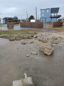
Water floods a yard and debris from a seawall is strewn about a property on Wilbur’s Point in Fairhaven after the 12/23/22 storm. Photo courtesy of Stephen Pietruska, Jr.
to protect the coastline.
She said the Mass. Coastal Flood Risk Model (MC-FRM) had tools online for people to see how their specific properties will fare in the future.
The group also discussed the Hurricane Barrier and the properties affected by being inside the protection of it, and those outside.
Mr. Cox noted that the HB itself is getting old. They are having trouble finding parts, so they avoid closing it if possible.
Mr. Cox also noted that the New Bedford of the harbor is not affected as much by storm surge because the piers are so high.
Fairhaven, on the other hand (and on the other side of the harbor) has a lot of low lying houses.
Mr. Ofsthun also talked a bit about marshes, saying “wetlands are a valuable asset to the town.”
He showed four maps showing loss of wetlands in the coming decades, detailing how many acres of wetlands will be converted to transitional marsh, high marsh, and tidal flats.
By the year 2070, there could be “dramatic changes to the wetland resources in town,” said Mr. Ofsthun.
The maps show that 471 acres “want to convert” to wetlands by 2070; transitional marsh habitat expands by 114 acres; high marsh habitat reduces by 515 acres; low marsh habitat expands up until the year 2050, then begins to convert to tidal flats; tidal flats expand by 501 acres.
Mr. Lavalette suggested that the town release the information in the town’s emergency preparedness plan, so residents will understand that the town is prepared.
“It’s a whole thick book,” he said.
Mr. Cox explained that it contains sensitive information and that is why it has not been released to the public.’
Mr. Lavalette said that a general overview of the protocol would make people feel comfortable knowing that the low lying areas have already been talked about.
Officials also had a survey available asking residents to detail when they experienced coastal flooding, how far away it was from their homes, in their homes, etc. The survey also asks residents to note their biggest concern related to coastal flooding.
To get the survey, contact Mr. Foley in the Planning Office, 508-979-4082, Ext. 9.
The group then headed to the two big maps on the table in the Town Hall banquet room, one with present day flood zone probabilities (see cover) and one with 2070 projected zones.
Mr. Ofsthun asked residents to circle on the maps the places they have seen flooding.
The next meeting will be held sometime in April. The topic will include what to do with critical infrastructure, evacuation routes, utilities.
The meeting and presentation are available on at FairhavenTV.com, (Government Acess-Public Hearings)
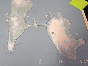
A flood map of Wilbur’s Point, Goulart Memorial Drive, and West Island shows the present day flood areas, and a couple of areas that regularly flood marked off by residents during the Municipal Vulnerability Preparedness meeting in Fairhaven on 2/8/23. Photo by Beth David
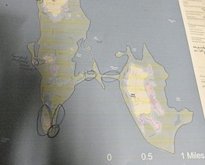
A flood map of Wilbur’s Point, Goulart Memorial Drive, and West Island shows the flood areas projected in 2070, and a couple of areas that already regularly flood marked off by residents during the Municipal Vulnerability Preparedness meeting in Fairhaven on 2/8/23. Photo by Beth David
•••
Click here to download the 2/16/23 issue: 02-16-23 MVP Maps
Support local journalism, donate to the Neighb News with PayPal


